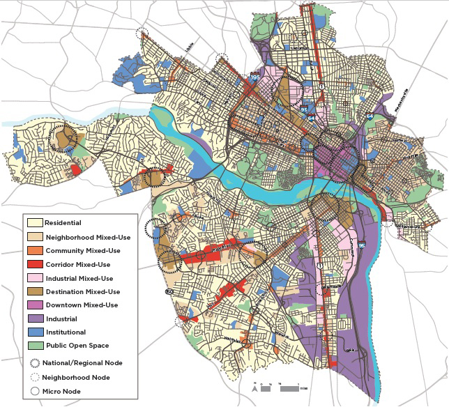
The latest version of the plan’s future land use map includes the new Community Mixed-Use designation, in orange. (Images courtesy Richmond 300)
Four years’ worth of work is nearing the finish line as city planners and consultants finalize their proposed update to Richmond’s master land use plan.
A so-called “pre-final” version of the Richmond 300 plan that was released in draft form earlier this year is set to be presented to the Planning Commission at its regular meeting today, with a vote on whether to recommend the document to the City Council scheduled for the commission’s next meeting Oct. 5.
Public comment on the plan will be taken at both meetings, which start at 1:30 p.m. and will be held via a virtual meeting platform. Links to the meetings will be posted on the city’s Legistar portal when the meetings begin.
Intended as a growth guide through the city’s tricentennial in 2037, the Richmond 300 plan has been tweaked since the draft was released in June. Feedback received through a series of virtual summits held since then, as well as from surveys and other correspondence, have driven some of the changes, which were presented to the plan’s advisory council last week.
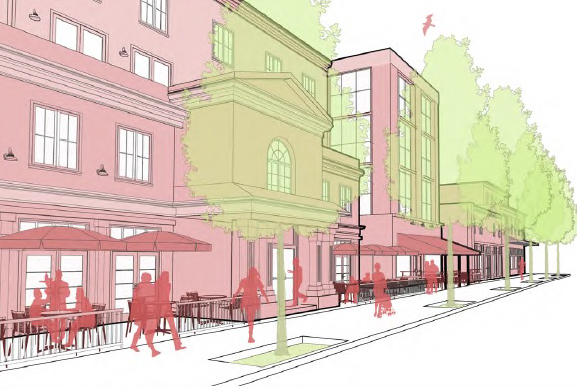
An illustration shows building density and heights envisioned for Community Mixed-Use in the plan.
Major changes include the addition of a new land use category, called Community Mixed-Use, which is now reflected on parts of the plan’s land use map. Described as falling between the plan’s Neighborhood Mixed-Use and Corridor Mixed-Use designations, the new category envisions different development intensity and building heights generally ranging from two to six stories.
The new designation — one of 10 in the plan that are intended to guide development and future zoning decisions — is applied in areas of the city including Patterson Avenue’s crossroads with Three Chopt Road and Libbie Avenue, parts of the Fan, MacArthur Avenue in Bellevue, Brookland Park Boulevard and the Six Points area.
Previous designations in some of those areas would have recommended building heights of up to six stories and varying densities. The new designation also is tailored to encourage more variety of buildings and uses that engage the adjacent streetscape.
Other mapping changes were made in areas including Randolph, Oregon Hill, Shockoe and Rocketts Landing. Randolph was largely changed from Neighborhood Mixed-Use to Residential, as feedback from the community indicated that its past mixed-use character was not expected to return or be encouraged.
Feedback from the Shockoe Alliance group and others led to much of that area being re-designated as Destination Mixed-Use, reflecting the group’s efforts to make Shockoe Bottom more of a destination for cultural and civic engagement. The riverfront stretch between Rocketts Landing and the eastern half of Tobacco Row is designated as Corridor Mixed-Use, which calls for building heights of up to 10 stories.
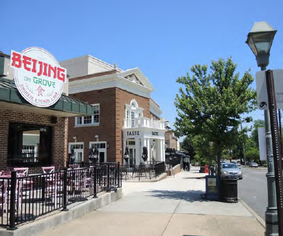
Carytown, Franklin Street downtown and the Libbie and Grove area are shown in the plan as examples of Community Mixed-Use corridors.
Other revisions to the plan include the addition of implementation and reporting metrics that are designed to show how the plan is being applied and keep its recommendations relevant and up-to-date over time.
The pre-final plan and associated summaries are posted on the Richmond 300 website. The public comment period for the plan has passed, but additional comments will be accepted at the commission meetings.
The approaching culmination of the years-long effort, which city planners have been steering with consultants from national engineering firm AECOM, coincides with separate but related planning efforts that also appear to be moving forward.
Last month, the commission adopted a pair of resolutions declaring the city’s intent to amend its B-3 General Business zoning district, which planners have described as problematic and inequitably applied across the city.
And this month, the commission endorsed city-initiated proposals that would facilitate a third phase of rezoning recommended in the city’s Pulse Corridor Plan, though a scheduled vote by City Council was continued. The council is now scheduled to consider the rezonings, which focus on land primarily north of Broad Street in and around the Carver and Newtowne West neighborhoods, at its Sept. 28 meeting.
"plan" - Google News
September 21, 2020 at 04:20PM
https://ift.tt/2RKTE94
City's master land use plan update entering homestretch - RichmondBizSense
"plan" - Google News
https://ift.tt/2un5VYV
Shoes Man Tutorial
Pos News Update
Meme Update
Korean Entertainment News
Japan News Update
Bagikan Berita Ini


0 Response to "City's master land use plan update entering homestretch - RichmondBizSense"
Post a Comment